 ENEA Antarctic Data Center
GNSS
Type of resources
Topics
INSPIRE themes
Keywords
Contact for the resource
Provided by
Formats
Representation types
Update frequencies
status
Scale
-
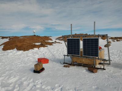
The Geodetic Observatory is based on continuous measurements of GNSS (Global Navigation Satellite System) data for the characterization of the neo-tectonics of a large area of the Northern Victoria Land. Particularly for the definition of a three-dimensional reference (plano-altimetric), and tidal waves, for the definition of a local and global absolute altimetric reference model. The permanent GNSS station 'LRSN', has been set on Mount Larsen (74° 57' 02,0" S - 161° 46' 10,1" E), 948 m a.s.l during the antarctic campaign 2015 - 2016. LRSN records data of GPS and GLONASS constellations, with an acquisition interval equal to 30 s. It is equipped with Tocpon Net-G3 GNSS receivers and chokering antennas, Topcon CR-G5 model (radome TPSH ), installed on steel pillars.
-
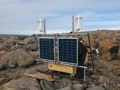
The Geodetic Observatory is based on continuous measurements of GNSS (Global Navigation Satellite System) data for the characterization of the neo-tectonics of a large area of the Northern Victoria Land. Particularly for the definition of a three-dimensional reference (plano-altimetric), and tidal waves, for the definition of a local and global absolute altimetric reference model. The permanent GNSS station 'INXP', has been set on Inexpressible Island (74° 56' 55,1" S - 163° 41' 06,3" E), 32 m a.s.l. during the antarctic campaign 2015 - 2016. INXP records data of GPS and GLONASS constellations, with an acquisition interval equal to 30 s. It is equipped with Tocpon Net-G3 GNSS receivers and chokering antennas, Topcon CR-G5 model (radome TPSH ), installed on steel pillars.
-
The aim of the MAss LOst in wind fluX (MALOX) project is to better understand the phenomenon of snow transport over a coastal area characterized by strong winds. MALOX relies on a multi-disciplinary approach based on both in situ and remote sensing measurements. Satellite data (MODIS, CALIPSO) analysis will provide spatial and vertical extension of the transport phenomenon. In situ microphysical, thermodynamic, and radiative observations will be aimed at determining the surface and column integrated water content, and characterizing the wind flux at local scale during the summer. Observations will be carried out also during the winter period to observe stronger transport events and to create a complete dataset which will provide a qualitative estimate of the mass loss due to blowing snow sublimation through the difference between the water content measured at two sites along the main wind path on steep slopes, one upstream of the convergence zone of the katabatic flux (Larsen Glacier, LS, 74°57'S 161°46'E) and the other downstream, near the coast (Inexpressible Island, InS, 74°56’S 163°41’E).